Reduce flood risk

H2020 PONDERFUL: The deurbanization of La Pletera

A de-construction project where a failed attempt of urbanization was substituted by a fully functional salt marsh ecosystem. La Pletera is a coastal salt marsh located in a very touristic zone and was affected by building works for a residential estate in the late 80s, and then discontinued in the 90s. After that, the area was protected and an ecological restoration project was developed, aimed to satisfy a long-held local aspiration: the restoration of the ecologically highly valuable saltmarsh that was partially destroyed by a construction project at the end of the 1980s.

The CLEVER Way: Hamburg, Neugraben-Fischbek

The CLEVER Cities project identified the primary planning goals for Neugraben-Fischbek district located in the South-West of the city of Hamburg was to: (a) creating a connective ‘Green Corridor’ to link a system of NbS interventions; (b) establishing horizontal greenery through the construction of green roofs on existing buildings; and (c) address the topic of environmental education and connect the youth with nature. 

Hamburg has aimed at addressing the following challenges, including:

  • Increase biodiversity and nature in the city: To address this, the city

  • ...

Øyer, Flood control

Drone photos of the Trodalen site after completion of the interventions, but before planting is fully completed

Flooding problems  during heavy precipitation in the Trobekken Creek may affect  a development project to establish 220 family housing units.

Through the H2020 project PHUSICOS the Trobekken Creek has been opened and re-meandered.  A buffer zone is established around the re-opened creek and is also combined with a sedimentation dam (check dam).

VALLADOLID (SPAIN) – RE-NATURING URBAN PLAN WITH NbS

The urban dominant model in Spain, which is characterized by the diversification of activities and population increase, has aggravated the urban risks and environmental problems that already existed, such as the high consumption of soil, energy, water, and air pollution. It is also important to highlight the significant difficulties caused by the increase in distances, and the permanent requirement of the use of the car. The strategic line of Valladolid is situated within the frame of the urban city model. Its objectives are to develop an innovative and entrepreneurial culture, and to...

IZMIR (TURKEY) – RE-NATURING URBAN PLAN WITH NbS

Izmir is a Turkish city with roughly 4 000 000 inhabitants. Located in the west coast of Anatolia, it is the country’s third most populous city. The local climate is Mediterranean, with long and hot summers and relatively mild winters.

Izmir is one of the oldest cities on the Mediterranean sea, with 8500 years of history. It is deeply cultured and offers a variety of historical sites. Izmir is also a modern and dynamic economical centre of its region. The local economy benefits from flourishing service industry followed by manufacturing and agriculture.

With its large...

Improve hydraulic capacity of canal system

The Fosetto (left) 
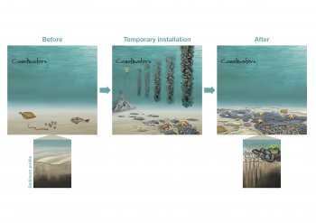
and Fossacio (right) canals before (upper) and after (lower) modification. (Photos: ADBS)

The main problem to solve with the implemented NbS measures is the runoff of soil and pollutants from the farmland to irrigation canals and from there to the nearby Lake Massaciuccoli on the Tuscan coast.

Through the H2020 project PHUSICOS two canals (canals Fossetto and Fossaccio) have been modified to improve the hydraulic capacity

Pages

Subscribe to Reduce flood risk