
Munich is Germany's third-largest city and the capital and the largest urban agglomeration of Bavaria with a population close to 1.5 million inhabitants. Including the surrounding suburban areas, the Munich agglomeration comprises up to 2.6 million inhabitants. Munich’s population is projected to reach 1.8 million by 2040. This expansive growth is the result of the strong economic development.
Munich is often known as the “economic capital” of Germany because it holds the headquarters of many companies, has the strongest economy of any German city with more than a million inhabitants and a low unemployment rate. This city is located around 50 km north of the northern Alps, which is within the Northern Alpine Foreland. It is built on the elevated plains of Upper Bavaria that results from the fluvio-glacial out-wash and previous glacier melts. The construction of the city benefited from its proximity to the Isar River, but its frequent and extreme flooding have long affected the settlements within the floodplain. Consequently, Munich benefits presently from vast housing-free riverine areas with high recreational potential.
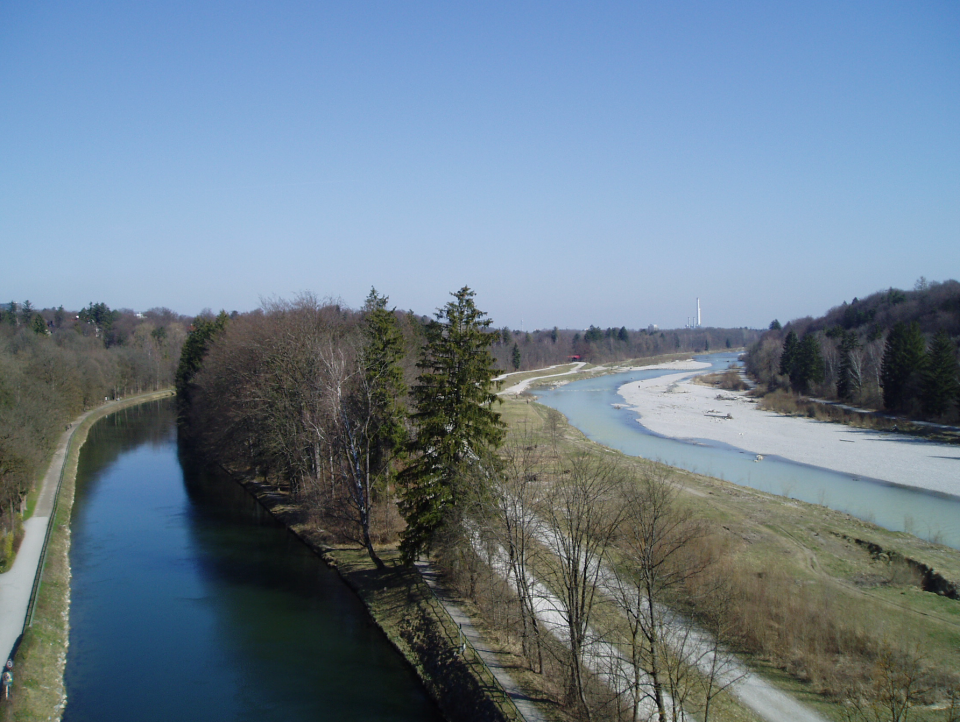
The Isar River is an alpine braided river with large gravel bars that sources in the Austrian Karwendel Mountains. It flows north through southern Germany and joins the Danube River in Deggendorf. It crosses the city of Munich (third-largest in Germany and the 12th largest city of Europe). The river has historically exibited a nival hydrological regime, which is characterized by short and violent flooding following massive snowmelts. But presently, flooding relies on summer rain events. Munich is within the oceanic climate zoning with warm to hot summers and cold winters. The nearby Alps cause precipitation increase and high rainfall volume during the summer.
Climate change is expected to increase extreme weather even in the alps and models suggest an increase of up to 25% of the rain volume within the Isar catchment area and an increase of 12% in the 100-year return period maximum discharge of the Isar River. Currently, the Isar River has high discharge variability throughout the year. In Munich, it varies between 8.63 m³/s during drought periods to 1050 m³/s during extreme flooding. Flooding of the Isar usually occurs within a few hours and recedes within a few days. Since medieval times, water of the river Isar was diverted into small canals to supply mills and industry. After a major flood in 1813 which killed more than 100 people and caused the collapse of a bridge of Munich, the first systematic hard engineering and flow regulation of the Isar was implemented. With great hydro-electrical potential, the late 19th and early 20th centuries saw a radical turn from this traditional use of the river and caused severe river degradations to the Isar. Today, 43 hydroelectric power plants change the character of the entire river.
Slideshow:
In the second part of the 20th century, three major challenges led towards a new thinking and the implementation of river restoration as a nature-based solution at the Isar.
First, after decades of river regulation, water diversion and hydro-morphological modifications, the resulting degraded morphological status and related losses of ecological and social quality triggered serious concerns from civil society and citizens.
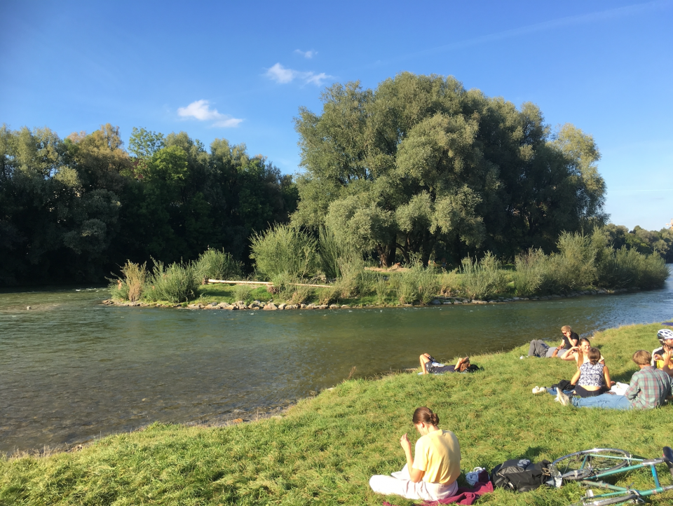
Second, the Isar River was very popular for swimming and other water-related outdoor recreational activities as one of the key elements of the local culture. While the Isar benefits from adjacent extensive agriculture and very little industry conducive for good water quality, with water diversion and urban sewage runoff flowed directly into the dry riverbed, the water quality had become unsafe for recreational uses despite the construction of the Sylvenstein Reservoir between 1954-1959 to ensure a minimum flow of water also in dry periods. Local municipalities and the district authorities that were responsible for public health were concerned about citizen health and safety. Due to the ratification of the European Bathing Water Legislation (1975), minimum flow requirements for ecological and social quality standards needed to be achieved and urged the city of Munich and the federal state water agencies to safeguard water related recreational uses.
Third, the riverbed volume could not contain the 100-year return period within the city of Munich. Despite the development of massive flood retention and protection infrastructure including the Sylvenstein reservoir, in the case of a HQ100 flood, the freeboard deficiency was over one meter and a solution was urgently required to decrease Munich’s exposure to flood risk.
Despite the urgency to take actions, it took more than forty years of intense efforts before the restoration of the Isar river in Munich transpired. The first plan of a river restoration was designed in 1970 by Alwin Seifert. From 1970 to 1985 civil society and lobbyists demanded for a near-natural river in Munich and pressured the politicians with very little success at the beginning. Numerous initiatives composed of citizens, municipalities and environmental associations were created. The EU Bathing directive enabled civil society and its representatives to legally demand restorative measures.
In 1980, the Bavarian Ministry of the Environment presented planning objectives for the Isar River targeting at improved water quality and increase of the minimum discharge in order to improve socio-ecological quality. An urban wastewater management plan was ratified the same year, resulting in a rapid improvement of water quality.
In 1985 with the expiration and renewal of water use rights for hydropower, a window of opportunity was opening. Public pressure on the Munich City Council led to the enforcement of a minimum annual outflow of 5 m³ / s in the Isar at the southern entrance into Munich. Between 1985 and 1990, advocacy groups gradually gained recognition and were invited to co-design the restoration. The hydraulic calculations investigating Munich’s exposure to HQ100 risk led to the formal start of planning in 1987 and this lasted until 1999, when energy producers, state offices for water management, nature conservationists, fishermen, as well as consultants from water management, hydraulics, biology, ecology, river morphology and landscape architecture collaboratively planned a new, more natural river morphology.
In 1995, working groups composed of experts and government administrations started to work together with local NGOs under the direction of both the State Office of Water Management and the City of Munich. Over 100,000 citizens altogether were involved during workshops and round table discussions to elaborate on planning goals and to map potential measures. The participative approach was decided by the Munich City Council and organized by the Münchner Forum, an NGO that aims to promote participation in urban development in Munich. Working groups with input from civil society designed a river that provides improved flood protection, while also being restored to near-natural conditions and providing much more outdoor recreation potential. The city´s Department of Building Construction was assigned the responsibility to implement the plan. The restoration was subdivided into three sections, beginning from the south of the city northwards towards the city centre. For the design of the last section of the river in the city center, the planning procedure took a decisive turn. The site was composed of sensitive and protected habitats with large gravel bars, historical monuments, and a narrow urban riverscape. To face these challenges, a competition was held to find the best solution for this extremely complicated stretch of river. This design selected was tested by the Technical University of Munich using a 1:20 scale model and flow simulation to ensure that the river design would be both capable to handle a HQ100 flood and would not change the characteristics of the protected habitat north of the restored section.
The Isar River restoration project in Munich achieved the first German award for river development ('Gewässerentwicklungspreis') in 2007. It was a predecessor of a nature-based solution to mitigate flood risk in urban areas, a pioneer in collaborative planning, which started out with advocacy groups and rapidly evolved into a Living Lab approach and is also a prime example for polycentric governance.
The governance and planning approach stimulated the cooperation between different decision-making institutions in order to decide on implementation beyond institutional boundaries and helped develop new, creative and innovative NbS. The Isar River restoration is widely recognized as a model of good practice and a well-known example of socio-ecological river planning.
The most evident benefits of the Isar River restoration are relate to:
- Increase communities’ sense of ownership and social interaction
- Reduce costs for water treatments
- Improve water quality.
- Increase well-being.
- Provision of health benefits.
- Changing image of the urban environment.
- Social inclusion
- Increase social interaction
- Social learning about location & importance of NbS.
- Increase stakeholder awareness & knowledge about NbS.
- Increase willingness to invest in NbS.
- Reduce load to sewer system.
- Increasing infiltration.
- Reduce run-off.
- Flood peak reduction.
- Reduce drought risk.
- Reduce flood risk.
- Increase infiltration / Water storage.
- Reduce risk of damages from drought.
- Developing climate change adaptation; improving risk management and resilience
- Enhancing sustainable urbanisation
At the international level, the Isar River restoration has been designated as a learning case by multiple networks and actors, including the River Network, the European Center for River Restoration, the European Climate Adaptation Platform Climate-ADAPT, the NATURVATION project and the PHUSICOS project which is funded by the European Union’s Horizon 2020 research and innovation program, and the SEE-River project funded by the European Union’s South-East Europe Transnational Cooperation Program.
Within the PHUSICOS project, the Isar River restoration helps to demonstrate the effectiveness of Nature-Based Solutions and their ability to reduce the impacts from small, frequent events (extensive risks) in rural mountain landscapes. Furthermore, it is meant to inspire nature-based solution design in three demonstrator cases. At the regional level, the restoration of the Isar from south of Munich to its mouth, of which the urban Isar is one important part, and especially the collaborative planning process inspired the Amper Rhei project. The Amper River is the largest tributary of the Isar River. The Amper Rhei project intends to achieve the same goals as that of the Isar-Plan but at a larger scale.
At the level of the Isar River, the success of the restoration in the south of Munich has driven discussions regarding the northern section within the city of Munich. Since approximately 10 years ago, experts and NGOs have started to meet in public round tables to find a suitable design together.
The main lessons highlighted by the Isar case are the following:
- The nature-oriented river landscape designed in the city centre of Munich demonstrated that a near-nature urban river development can be achieved.
- Civil society can influence major socio-ecological changes in the riverscape.
- When the citizens care, the politicians take action.
- Mutual trust and understanding among different stakeholders is a key of successful collaborative planning, although it may take time. Civil society should be involved early on in collaborative planning to take their concerns on board and thus reduce the risk of later strong conflicts. Formal planning procedures such as planning competitions should be adapted to enable participation.
- Processes and negotiations need time and patience.
- Long-term collaboration helps to avoid planning mistakes or pitfalls.
- Importance of understanding how to take advantage of the “windows of opportunities” to re-establish hydro-morphological processes
- Socio-cultural and ecological needs should be balanced to achieve resilience
- Flood protection does not mean ecological degradation
- Better management of recreational use and raising awareness among citizens for nature and river conservation is needed. Moreover, the project demonstrated that collaborative processes may be more time consuming but promote innovations.
Further information
- 11. Sustainable Cities and Communities
- 13. Climate Action