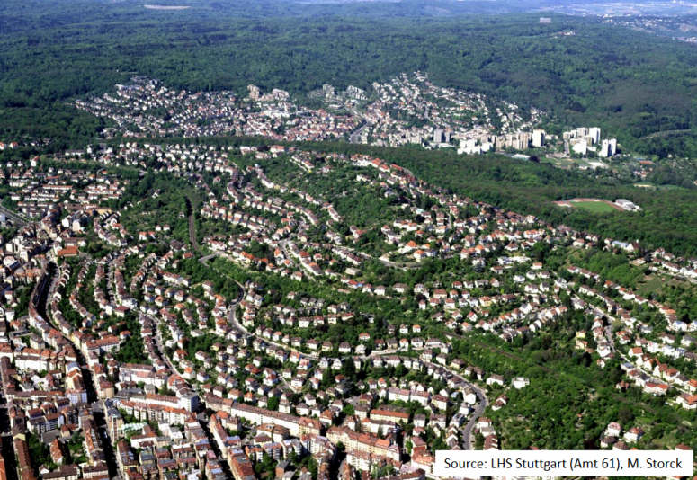
City of Stuttgart is situated in a mild-climate valley basin with low wind speeds. There's a major automobile manufacturing industry and a high volume of traffic. Moreover, the city is in certain areas (e.g. Stuttgart-West) very densely populated. Correspondingly, the sealing degree is high. This led to the development of a Climate Atlas for the Stuttgart region with attention to the distribution of temperature and cold air flows.
Green corridors are linear parks that help renature cities by connecting green areas to one another to form urban green infrastructure networks. They are often retrofitted along areas of abandoned traffic infrastructure, e.g. railway lines, or waterways to create interconnecting parks. Green corridors are particularly beneficial for urban biodiversity as well as cooling cities and improving air quality by providing cool air pathways.
The city of Stuttgart took this concept and implemented it on a large, city-wide scale. Located in a valley with low wind speeds, the city is prone to the urban heat island effect and poor air quality. To overcome these challenges, Stuttgart implemented a natural green belt strategy to create pathways for winds to sweep down from the hills to ventilate the city. This entailed zoning and regulations limiting real estate and other development along green belts and divides. Additional benefits of this strategy is increasing connectivity between rural areas and the city center, enhancing biodiversity and supporting the wellbeing of citizens by ensuring more open space in an otherwise highly built-up urban environment.
In the case of Stuttgart, the city’s topographic features, such as stream and meadow valleys, guided the designation of green belts and preferred ventilation pathways. Based on urban climatic mapping in the Regional Plan of Stuttgart (1998), four cool air corridors – the Nesenbachtal valley, Feuerbachtal valley, the Lindenbachtal valley and the Rohrakker valley systems – were marked for special zoning and a ban on encroachment by building. These were chosen on the basis of channeling cooler air through preserved, undeveloped park areas on hillsides as well as low-density developed areas. The result was also intended to connect rural areas to the city center. Within the city itself, the air flow corridors were connected to existing parks, where possible, to reach local neighbourhoods. The preferred width of the green corridors is a minimum of 100 m.
Today, a “climate atlas” provides basic information about wind, solar radiation, temperature and precipitation in the Stuttgart region. Based on this information, statements are made as to where cold air is produced and how it is exchanged. The so-called climate analysis maps provide information on air pollution
|
Air pollution |
|
|
Heat island effect |
|
|
Rainwater drainage/runoff |
|
|
Ecological and social connectivity |
|
- Developing climate change adaptation; improving risk management and resilience
- Reducing temperature at meso or micro scale
- Restoring ecosystems and their functions
- Increase Biodiversity
- Improve air quality
- Increase well-being
- Provision of health benefits
High transferability to urban areas being located in a similar topographical situation.
Stuttgart is an industrial, prosperous city with very high real estate prices. The construction ban and other zoning policies to support the green ventilation network required decision makers to negotiate the city’s priorities between competing interests. The supply of fresh air and heat island management had to be weighed against the loss of potential tax revenues from construction as well as the social dimensions of high housing costs. Hence, the main challenge for the project were considerations of giving greater weight to other concerns (e.g. economic interests, housing needs, etc.)
The main success factors for the project were that the city institutionalised the integration of urban climatic concerns into the planning and that today each individual planning is examined and adapted on the basis of the principles and concepts of the cold air regime of the ventilation corridors.Furthermore, the impact mechanisms of the cold air regime are well described in the climate atlas, so there is a transparent basis for the measures that are undertaken.
250.000 Euro
Verband Region Stuttgart – Körperschaft des öffentlichen Rechts
Kronenstraße 25
70174 Stuttgart
Municipality of Stuttgart
Office for Environmental Protection, Department of Urban Climatology
Gaisburgstraße 4, 70182 Stuttgart, Germany
Verband Region Stuttgart – Körperschaft des öffentlichen Rechts
Kronenstraße 25
70174 Stuttgart
Rainer Kapp
Municipality of Stuttgart
Office for Environmental Protection, Department of Urban Climatology
Gaisburgstraße 4, 70182 Stuttgart, Germany
Tel: +49 711 216 88625
E-mail: Rainer.Kapp@stuttgart.de
- 3. Good Health and Well-being
- 11. Sustainable Cities and Communities